
It’s not just a metal band from the Netherlands.
Aftershocks rumble at Mount Rainier
The effects of this weekend’s magnitude 4.5 earthquake at Mount Rainier may simmer for several more days as low-level aftershocks continue, scientists said Sunday.
The quake caused minor rockslides in some areas, but all roads were open, with visitors cautioned to watch for falling rocks.
More of a curiosity than a threat, the quake occurred just before 8 p.m. Saturday.
It is uncommon to have a quake centered on the east side of the mountain — in this case, about two miles beneath Cowlitz Chimney in Lewis County, said Tom Yelin, a geophysicist at the University of Washington seismology lab.
“There haven’t been many of those in the last 30 to 40 years,” Yelin said. The last one was a magnitude 4.7 quake in 1974.
I’ve stated here in the past that one of the reasons I’ve decided to stay in the liberal armpit of the United States of America instead of somewhere more sensible, like Montana, is because of the gorgeous scenery.
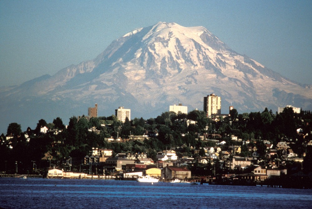
I can go from Mount Rainier, St. Helens or any of the other multitude of Alpine peaks that makes Washington’s terrain more like Switzerland than any other state in the nation all the way down to any of the beaches along our hundreds of miles of coastline in an hour.
But I know the dangers that come with such opportunity: Tsunamis, floods, earthquakes, and most devastating of all, volcanic eruptions.
For those not in the know, a “Lahar” is basically the mudflow that comes from the swift melting of glacial ice during a volcanic eruption. There are three main paths for the Rainier lahar on the west side of the mountain, the largest of which runs through the town of Orting, which has seen it’s population double if not triple in the last decade.
Scary thoughts.
Calling Rainier just a “mountain” is somewhat disingenuous. It is, and has been for over 1000 years, the largest dormant volcano on the west coast. I have little to no doubt that it will pop in my lifetime, which is why I have made preparations and arrangements.
You have too, I suppose?
Hell yeah.
Step #1: Residence is not in the Lahar area. My house is up high on the east hill, far back from the edge and is sheltered from direct blast effects by a bigger hill. No big trees around to fall on my house, either.
(Btw, this caused some marital problems with the wife when shopping for a house. She kept finding houses she liked in Puyallup, and I would simply nod and then point to the “Evacutaion Route” signs right on the street and say “nope”. I actually won this one. 🙂
Step #2: Earthquake prep on the house. Check!
Step #3: Survival and emergency supplies (in-progress)
Step #4: Guns and ammo. Check, double check and triple check!
Step #5: Worst-case scenario – evacuation routes planned and destinations identified. My goal is to have everything ready so we can load and go in 20 minutes, if need be. Not there yet, but should be by January. In-progress.
I agree completely – I think Rainier will blow its top sometime in my lifetime.
Someone gave me a hard time about my “paranoia” (hint: he lives in Puyallup) – he said the odds were greater than one in a million it would happen soon. I replied by asking if he played the lottery. He said he did, and I asked why he was optimistic on those one in a million odds and ignorant on the other? Based on the look on his face, I might have won that one too…
R.S.
As a Boy Scout visiting Crater Lake, the little 3-D model of Mount Mazama really blew my mind. It’s hard to believe a mountain can blow that much of its mass all over the place, but there’s no denying it when the Ranger lifts off the top half of the model to reveal present-day Crater Lake.
Sorry, but Colorado is the Switzerland of America. Indeed, the area around Ouray is known by that moniker. We have 53 peaks over 14,000 ft. How many do you have?
We have only one peak over 14K, and that is Mt. Rainier. But is not the height, since WA is at sea level and CO is on the continental divide, it is the sheer number of peaks.
We have over 300 individual ones over 5K with most being over 7K.
Mountain envy. Haven’t seen it for years, since I climbed with the Mazamas.
Hmm. I thought Wallowa Valley in Oregon claimed to be the Switzerland of America? I’m thinking that’s a good retirement spot. Snow-clad peaks that are a lot like the Sierra Nevada, a California-like climate, an alpine lake (well, okay, a reservoir), a huge wilderness area in your backyard, plentiful hunting and varminting, low low housing prices (for now), and — most importantly –shall-issue CCWs!
See: http://www.josephoregon.com/panoindexpage.htm for some incredible panoramic shots. I’m hoping we’ll be able to drive through this area on the way to Boomershoot 2007 so I can see it with my own eyes.
Unemployment’s pretty high though. If I could just figure out how to make an income up there, I’d move in a second.
To the previous poster, Actually comparing the Coloardo rockies to the cascades is a joke. For one thing most of the rockies in Coloardo are NOT Glaciated. The North Cascades of Washington state contain more glacial ice then all of the lower 48 combined.
My second point is that a mountain is not only measured by its height, but by its elevation gain. Much of the coloardo rockies start at nearly 10K but only rise by 3-4K. Whereas much of the Cascades and Olympics easily rise 7-8K above surrounding peaks. They are more rugged.
Ask any alpine climber and they will tell you the North Cascades blow the Colorado rockies out of the water =)